NASA
Sea Level Change
Skip Navigation
menu close modal
  • News & Features
    • Sea Level News
    • Scientist Interviews
    • News Briefs
  • Understanding Sea Level
    • Overview
    • Global Sea Level
    • Regional Sea Level
    • By the Numbers
    • Key Indicators
  • Science Team
    • Overview
    • Projects
    • Team Members
    • Presentations
  • Data
    • Data Search
    • Data Tools
    • Missions
  • Climate Tools
  • Resources
    • Multimedia
    • Publications
    • Glossary
  • FAQ
Stay Connected
Previous Article
Video: Ocean Flows Under Pine Island Glacier, Antarctica
Next Article
Video: Sentinel-6 Michael Freilich Satellite Family Tree

Multimedia

Animated GIF: Sentinel-6 Michael Freilich

Animated GIF: Sentinel-6 Michael Freilich

November 11, 2020

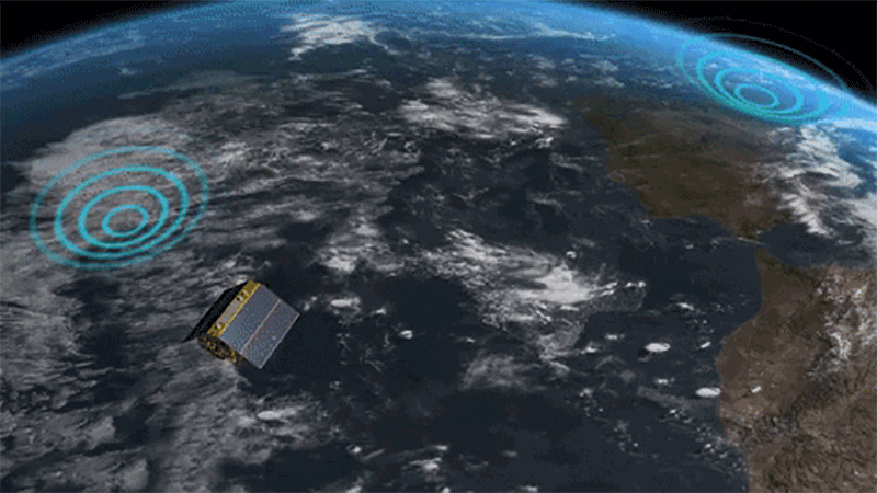
Animated GIF of the Sentinel-6 Michael Freilich satellite, scheduled to launch in November 2020. More are available to download here.

Credit

NASA

ENLARGE

Downloads

800px gif (12.8 MB)

Featured Resources

  • Video: Tracking 30 Years of Sea Level Rise
    Video: Tracking 30 Years of Sea Level Rise
  • Video: Global Ocean Tides
    Video: Global Ocean Tides
  • Video: Ocean Flow Vignettes
    Video: Ocean Flow Vignettes
› more resources

Related Resources

Animated GIF of Oceans Melting Greenland GLISTIN-A instrument observing Greenland's glacier front; aircraft deploying ocean probes.

More
Oceans Melting Greenland (OMG) GLISTIN-A
Oceans Melting Greenland (OMG) GLISTIN-A & AXCTD - Animated GIF

Animated GIF of Oceans Melting Greenland (OMG) ship and airborne AIRGrav instrument.

More
Oceans Melting Greenland (OMG) ship & airborne AIRGrav instrument
Oceans Melting Greenland (OMG) ship & AIRGrav instrument - Animated GIF

Visualization of the formation of an El Niño event towards the end of 2009 followed by a 2010 La Niña event.

More
2009 El Niño and 2010 La Niña (3D-stereoscopic version)

An animation with voiceover narration showing the global ocean tides as a complex system of rotating and trapped waves with a mixture of frequencies.

More
Video: Global Ocean Tides

Video: Oceans Melting Greenland (OMG) Principal Investigator Josh Willis recaps the last leg of the campaign's survey of northwest Greenland.

More
Oceans Melting Greenland 9/28/16 update

Animation showing changes in Greenland ice mass since 2002 based on satellite data.

More
Video: Greenland Ice Mass Loss 2002-2020

1997 and 2015 El Niño animations made from data collected by the TOPEX/Poseidon (1997) and the OSTM/Jason-2 (2015) satellites

More
El Niño: 1997 vs. 2015

Data from TOPEX/Poseidon was used to produce a computer model of 16 days of tide height.

More
TOPEX/Poseidon flat earth tide height model

The great Ice Age glaciers rise and fall in thousands of years per second.

More
Video: Watch glaciers rise, fall in thousands of years per second

NASA is studying the Earth's ice and water to better understand how sea level rise might affect us all.

More
Melting ice, rising seas

Visualization of a gravity model created with data from NASA's Gravity Recovery and Climate Experiment (GRACE).

More
GRACE global gravity animation

B-roll for media on the sea level-observing Sentinel-6 Michael Freilich satellite.

More
Sentinel-6 Michael Freilich Media Reel
Video: Sentinel-6 Michael Freilich Media Reel

NASA's Oceans Melting Greenland (OMG) and Operation IceBridge missions investigate Greenland's thinning ice sheets from above and below.

More
Greenland's thinning ice

TOPEX-Poseidon altimeter sea level anomaly in the Pacific from August 1, 1996 to August 3, 1997.

More
El Niño: TOPEX/Poseidon altimeter sea level anomaly from August 1, 1996 to August 3, 1997

Visualization of monthly changes in ocean bottom pressure data obtained by the GRACE satellites from November 2002 to January 2012.

More
Ocean bottom pressure from GRACE

Image of ocean winds near the surface as observed by NASA's ISS-RapidScat on the International Space Station.

More
RapidScat observes El Niño

This visualization shows total sea level change between 1992 and 2019, based on data collected from the TOPEX/Poseidon, Jason-1, Jason-2, and Jason-3 satellites.

More
Video: 27-Year Sea Level Rise

Images show changes in Antarctic ice mass since 2003.

More
Antarctic ice loss 2003-2013

Video: Oceans Melting Greenland (OMG) Principal Investigator Josh Willis reports about perfect conditions in northwest Greenland that led to a great day for data collection.

More
Oceans Melting Greenland 9/24/16 update

Sea surface height-monitoring satellite Jason-3 liftoff from Vandenberg Air Force Base aboard a SpaceX Falcon 9 rocket.

More
Jason-3 liftoff on Falcon 9 rocket

TOPEX/Poseidon altimeter sea level anomaly in the Pacific from September 15, 1996 to September 21, 1997.

More
El Niño: TOPEX/Poseidon altimeter sea level anomaly from September 15, 1996 to September 21, 1997

A visualization of U.S. East Coast ocean flows

More
Video: Ocean Flow Vignettes

A poster titled 'Measuring Greenland's Ice' depicting the various measurement mechanisms that will be utilized by the Oceans Melting Greenland (OMG) mission.

More
Greenland's melting ice (poster)
Measuring Greenland's ice (poster)

Animation of the average yearly change in global land ice mass during 2003-2010 from all of the world's glaciers and ice caps (excluding Greenland and Antarctica).

More
Global mass balance from GRACE

Visualization of the locations of the ARGO buoy array over time (with faster camera move).

More
ARGO float animation #2
more resources

Newsletter

Stay Connected

News & Features

    • Sea Level News
    • Scientist Interviews
    • News Briefs

Understanding Sea Level

    • Overview
    • Global Sea Level
    • Regional Sea Level
    • By the Numbers
    • Key Indicators

Science Team

    • Overview
    • Projects
    • Team Members
    • Presentations

Data

    • Data Search
    • Data Tools
    • Missions

Climate Tools

    • Climate Tools

Resources

    • Multimedia
    • Publications
    • Glossary

FAQ

    • FAQ
  • Feedback
  • Privacy Policy

Site Manager: Carmen Blackwood
NASA Responsible Official: Stephen Berrick