News | January 18, 2017
The price of rising seas: drowning wetlands
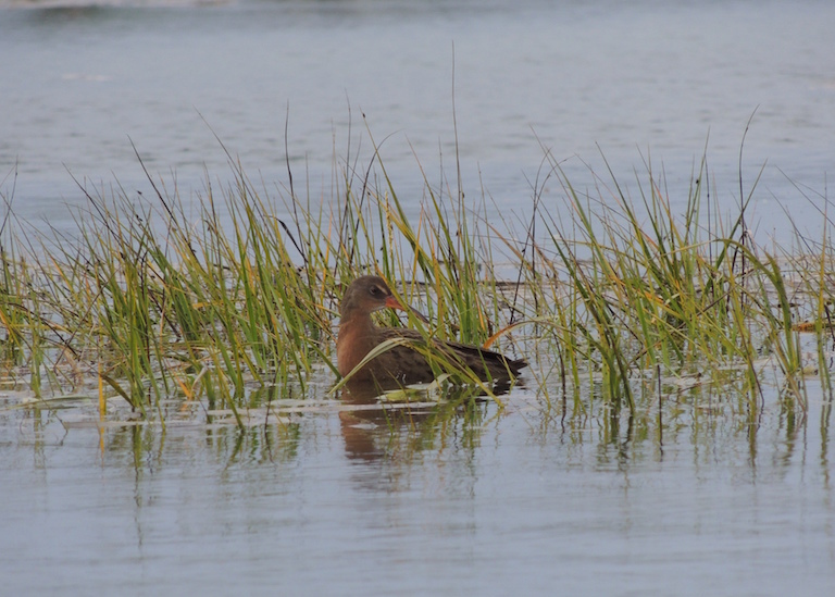
Rising sea levels could inundate wetland habitat for the endangered light-footed Ridgway's rail, shown here in the Seal Beach National Wildlife Refuge south of Los Angeles. The refuge is among many on the U.S. West Coast that could be lost in the decades ahead. Photo by Kirk Gilligan, U.S. Fish and Wildlife Service.
Some of California’s most cherished coastal wetlands, where endangered birds chatter and green growth thrives, could turn to mudflats by the middle of the century.
By the end of the century, they could be gone.
New research based on years of observation says rising sea levels might well outpace the ability of coastal wetlands to adapt, inundating them before they have time to colonize higher elevations.
Up and down the U.S. West Coast, from northern Washington to Southern California, the gradual watery invasion would first eliminate key plant and animal species. Then, in later decades, it would simply drown many of the former wetlands, said Karen Thorne, lead author in a series of recent reports and a research ecologist at the U.S. Geological Survey Western Ecological Research Center in San Francisco Bay.
“The biggest determining factor if wetlands are still here 100 years from now is the rate of sea level rise,” Thorne said. “If sea level rise is really on a higher level, then it’s going to be a different world in the future.”
Thorne and her research team compiled ground-based measurements of marsh elevation, water levels and quality, and plant and animal abundance, along with historical data based on sediment cores, in one of the most broad-ranging studies of its kind. The measurements, collected from 2012 to 2015, covered 18 separate sites, with some coring trends spanning centuries. And the habitats varied immensely, from the cool, wet, forest-hugging marshlands of the north to the warm and often parched wetlands of the south, most of them hemmed in by agriculture or urban development.
The data were then fed into computer models under a variety of future sea-level rise scenarios, from low to moderate to high, to try to project how the various wetland habitats would respond. The bulk of the modeling results came from WARMER (the Wetland Accretion Response Model for Ecosystem Resilience), which matches rates of soil accretion by the marshes—in essence, their ability to create new land upon which future marshes could grow—against sea level rise.
Troubling forecast
The news from the modeling wasn’t good. In most of the scenarios, the wetlands lost ground in the race against rising seas.
“Southern California was the most vulnerable to submergence or drowning,” Thorne said.
The study sites were coastal estuaries where, at least historically, river systems met the sea, their water channels rising and falling with the tide as they meandered among islands of wetland vegetation.
In Southern California, however, freshwater flow has become a trickle in many wetland systems—increasing their vulnerability.
“In the near term, I think it has to do with really two factors,” she said. “One is that the rate of sea level rise is higher in that portion of California. And also, these estuaries are really modified. There rarely is freshwater flow into them.”
For many wetlands, it’s a question not of “if,” but of “when.”
“You combine the disruption of natural processes with sea level rise, and it really means we have set these places up to not respond well,” Thorne said. “Looking at it all at once, from Puget Sound in Washington to San Diego, California, you can really see that wetlands are vulnerable to drowning, under high rates of sea level rise, by the end of the century.”
For nest-weaving rail, a threatened domain
One of the most dramatic effects could be seen at the Seal Beach National Wildlife Refuge. This 965-acre refuge, part of the Seal Beach Naval Weapons Station, is considered a jewel among Southern California wetlands. It has become a kind of display case for plants and animals that have vanished elsewhere, such as the chicken-like light-footed Ridgway’s rail (also known as the light-footed clapper rail), a species that weaves floating nests and tethers them to cordgrass.
Seal Beach is one of three significant Southern California wetlands that, under mid to high sea-level scenarios, begin transitioning to tidal mudflats by about 2060, the modeling shows. By 2080, the process is complete. And by the end of the century, Seal Beach becomes completely subtidal—a once thriving ecosystem drowned beneath the waves.
By 2110, Thorne said, “there’s no longer vegetation, or even a mudflat.” Subsidence of the tidal basin, likely the result of water or oil and gas extraction, is also adding further strain to the system.
The results of analyses by the research team, which included the U.S. Geological Survey, Oregon State University and the University of California at Los Angeles and at Davis, are spread over several reports published since 2015.
In seven Southern California marshes, studied between 2012 and 2014, the mid-range sea level scenarios brought a loss of higher-elevation marshland by 2110. The Morro and Tijuana marshes turned mostly to mudflats by 2100.
High rates of sea level rise eventually turned all the marshes to mudflats.
Marshes farther north fared better, the modeling showed. Nine Pacific Northwest marshes, studied between 2012 and 2015, also lost higher elevation marsh habitat by 2110 under mid-range sea level scenarios. But most converted to lower-elevation marshes instead of mudflats.
Still, two of them—Oregon’s Bull Island and Siletz marshes—lost all marsh vegetation. And more than half the sites turned to mudflats under the high sea-level-rise scenarios.
“The message is that estuaries will be different in the future with sea level rise, assuming there is no intervention by humans,” Thorne said. “The change will be different services to both wildlife and people. We found that wetlands cannot keep pace with sea level rise in many estuaries; there can be extensive habitat loss for wetlands wildlife without intervention management strategies.”
Read the U.S. Geological Survey report on projected wetland losses for California:
Effects of Climate Change on Tidal marshes along a Latitudinal Gradient in California
Read the U.S. Geological Survey report on projected wetland losses for the Pacific Northwest:
