News | September 3, 2024
NASA Sea Level Team Examines an Island Nation at Risk

Kiritimati Island (pronounced "Ki-ris-mas" – Christmas Island), one of the Kiribati islands in the South Pacific, which will likely face increased flood risk from rising sea levels according to a recent report. Image credit: a mosaic of images from the International Space Station provided by the Earth Sciences and Image Analysis Laboratory at Johnson Space Center
The question: When, and how severely, will future sea level rise affect the island nation of Kiribati in the South Pacific?
The answer: A recent assessment by NASA’s Sea Level Change Team finds that the far-flung Kiribati islands face significant – and rapidly increasing – flood risk as sea levels rise. The team’s appraisal of potential threats, similar toa 2023 report on another Pacific island nation, Tuvalu, relies on surface and satellite data, computer modeling, and projections of sea level rise in the decades to come. Among the science team’s findings:
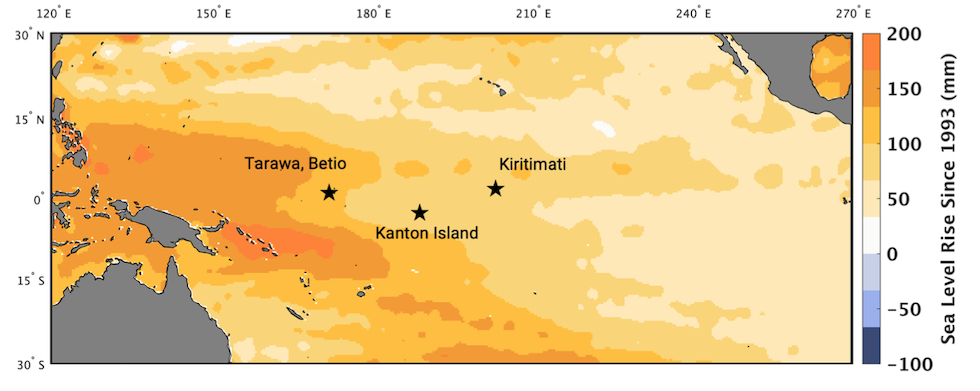
- The three South Pacific island groups that make up Kiribati, with a separation between the easternmost and westernmost islands wider than the contiguous United States, have seen sea level rise 2 to 4 inches (5 to 11 centimeters) over the past 30 years.
- By 2050, the islands will likely see an additional 6 to nearly 12 inches (15 to 30 centimeters).
- By the end of the century, depending on future greenhouse-gas emissions and the intensity of global warming, Kiribati sea level could rise by 1 ½ to more than 3 feet (50 to 100 centimeters). In an unlikely but worst-case scenario, it could even approach 6 ½ feet (2 meters).
- Both the frequency and severity of flooding will rise as the decades progress: All islands will likely experience more than 100 days of flooding every year by century’s end.

As with all such projections, the team’s findings come with caveats. Their report is a high-level summary of future flood threats based on available data, intended to help inform – but not direct – decisions by planners on the ground as they confront the effects of climate change. Further study of other potential effects will be needed. The sinking or rising of the land itself, which can alter sea level estimates, could vary among the widely separated islands, and will require further observations to pin down. And while broadscale sea level change is captured by existing satellites, changes close to the coast remain largely unknown. The SWOT (Surface Water and Ocean Topography) satellite, launched in 2022, is expected to measure near-shore sea levels far more closely than its predecessors.
Why it’s important: The new report is part of a series of localized “closer looks” by the NASA sea level team as it pursues a science-to-action strategy. These technical assessments are designed to make sea level science more accessible, and useful, to coastal planners and decision makers in places like Kiribati, helping them adapt to an altered environment as Earth warms and sea levels rise.
