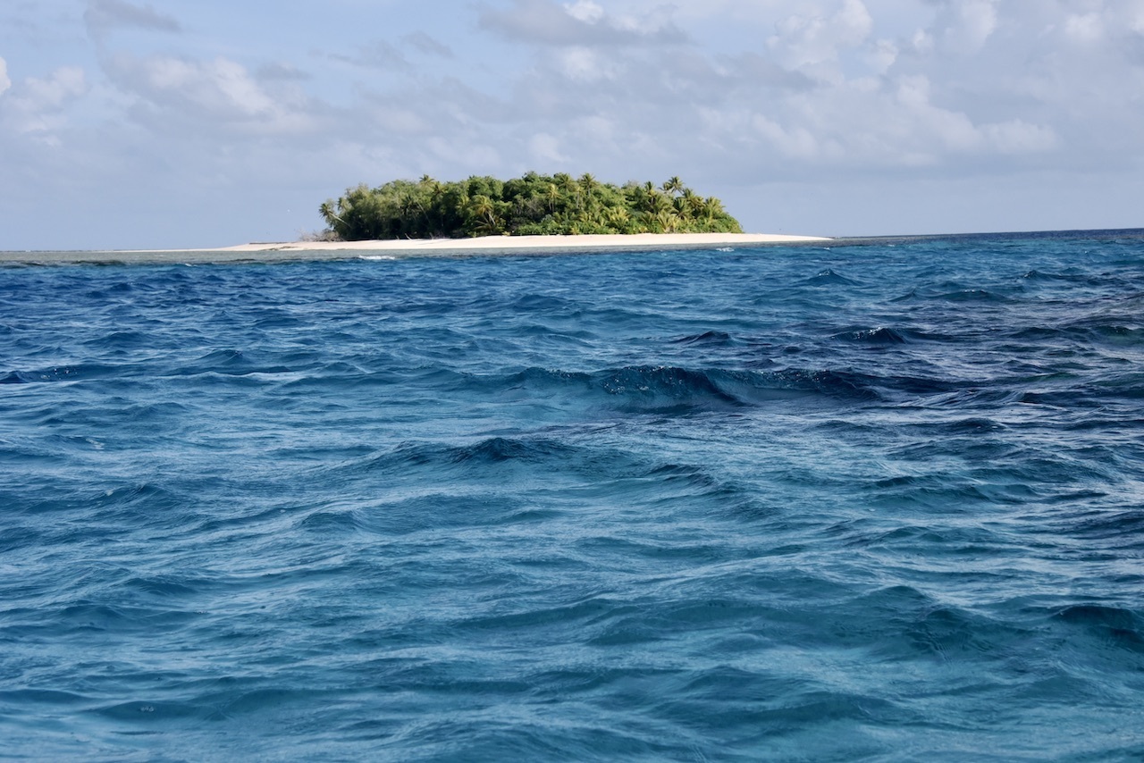
The dangers of rising sea levels are perhaps nowhere more stark than the island nation of Tuvalu in the South Pacific: increased coastal flooding, worsening storm damage, and more threats to come.
To help Tuvalu and other low-lying island nations prepare for a changing climate, NASA’s Sea Level Change Team is partnering with a United Nations support initiative. The idea: to provide a solid scientific foundation for understanding future sea level rise and its potential effects on coastal communities.
In a first step, the NASA team has released a new technical assessment of the island nation’s future environmental prospects. The report includes projections for how fast sea levels are likely to rise and how frequently flooding might occur, and concludes that assessments and increased scientific monitoring could improve planning for potentially catastrophic events.
The NASA science report is designed to advance the goals of the Rising Nations Initiative (RNI), a project set in motion by the U.N. Global Centre for Climate Mobility.
“The RNI was launched by heads of state in September 2022, and works to protect the statehood of the Pacific atoll countries, preserve their sovereignty and safeguard their rights and heritage,” said Professor Kamal Amakrane, managing director of the Global Centre for Climate Mobility. “It marks remarkable leadership by the atoll countries to determine their own futures, and we at the RNI are honored to support this, working closely with renowned global institutions like NASA.”
Leaders in Tuvalu say increased scientific support is vital.
“I welcome the partnership between NASA and the Rising Nations Initiative to help provide the much-needed data, science and monitoring to support Tuvalu and the Pacific region,” said Seve Paeniu, Tuvalu’s minister of finance and climate change. “This effort is key to ensuring proper early warning and data-based and science-led policy design.”
Two leaders of the NASA team, Drs. Nadya Vinogradova Shiffer and Ben Hamlington, presented a summary of the report to the United Nations on June 22, 2023. Those in attendance included a dozen representatives and ambassadors from member states, as well as the president-elect of the U.N. General Assembly. Both scientists also visited Tuvalu for a firsthand look at the effects there of rising seas.
The scientists met with Paeniu and Amakrane, and spoke with island residents to better understand how NASA could support Tuvalu and the U.N. effort.
In this pilot partnership, the team saw firsthand how NASA climate data can inform decisions and actions, said Vinogradova Shiffer, who directs the NASA Ocean Physics program and the Sea Level Change Team at NASA Headquarters in Washington.
“We also learned that international policy-making and diplomatic campaigns can get complex and lengthy, and thus require sustained climate information for years to centuries so that political and legal decisions that are made today ensure nations’ best interests in the long run,” she said. “It’s truly a team effort, where NASA stays committed to play its scientific role.”

The scientists’ presentations were well received, said Head of Secretariat Yu Ping Chan of the Rising Nations Initiative.
At the U.N., “there is strong support and demand for NASA to continue to provide the needed data, analysis and monitoring of sea level rise, particularly in helping to support efforts to address its impacts,” she wrote to the scientists.
The report presents a detailed portrait of the island group’s struggle with rising seas. Sea level in Tuvalu is nearly 6 inches (0.15 meters) higher than it was 30 years ago, according to the assessment. The average rate of increase – about 0.2 inches or 5 millimeters per year – is expected to more than double by 2100, and is already 1.5 times faster than the global average. Sea level in coastal areas, or relative sea level, is projected to rise 8 inches (20 centimeters) or more by 2050 and perhaps another 20 to 40 inches (1/2 to 1 meter) by the end of the century.
This will pose challenges for Tuvalu’s low-lying islands. Much of their land area, along with critical infrastructure, will be below the average high tide by 2050. And future sea level rise will worsen the effects of tides, waves, and storms, greatly increasing the frequency and severity of periodic flooding. While scientists’ projections of present-day trends into the future can vary, in general the higher the level of warming the higher seas are expected to rise.
“We can already see from the data that small-scale ocean variability, storms, high tides and sea level rise are all combining to cause flooding in Tuvalu,” said Hamlington, a researcher based at NASA’s Jet Propulsion Laboratory in Southern California who leads the NASA Sea Level Change Team. “Visiting Tuvalu made the extent of the problem clear, and hearing first-hand accounts of what is happening was eye-opening for us.”
Tuvalu is working on a plan for the future called the Tuvalu Coastal Adaptation Project. Detailed scientific assessments, including the one just released by NASA, as well as increased monitoring of sea level change around the islands can enhance that effort, Hamlington said.
Essential scientific data will come from the Surface Water and Ocean Topography (SWOT) satellite, recently launched by NASA and CNES (Centre national d’études spatiales) which can measure sea level at higher resolution and closer to the coast than any of its orbital predecessors.
“Observing sea level with new instruments like SWOT can support the planning efforts of Tuvalu, and support initiatives like the U.N. RNI,” Hamlington said. “The broad coverage of satellites will also allow us to provide similar information for other Pacific Islands.”
Previous observations provided the island nation with other items for its to-do list. The islands, for instance, not only are seeing the effects of rising sea levels, but also variable rates of sinking – subsidence – of some land areas. More extensive measurements of subsidence could enhance planning efforts.
Although Tuvalu presents an urgent need for scientific assistance, rising seas and climate change remain a global threat, leading NASA and other science-based agencies to make similar assessments in a variety of locations. The Tuvalu report is an early example of the NASA team’s new “Science to Action” emphasis – using science to support action on sea level rise, and making science an easily accessible tool for planners and residents. Projects that are being addressed under this framework, including the Tuvalu report, can be found on the NASA Sea Level Portal.
“I’ve been looking at Earth’s rising ocean using the satellite bird’s-eye-view for decades,” Vinogradova Shiffer said. “But it is always humbling to visit the sites in person, to talk to people about the changes they see.”
