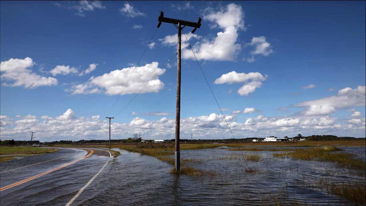
Minor flooding events are becoming more commonplace along U.S. coastlines, and recent estimates show they will be even more frequent in coming decades as sea levels continue to rise.
Now a NASA science team is seeking deeper understanding of the coastal effects of sea level change, measuring to greater precision the factors that contribute to these flooding events. They can add up to changes in seasonal flood patterns and present significant challenges for local and regional planners.
The team’s findings also helped create a “Flooding Days Projection Tool” now available to the public on the NASA Sea Level Portal. The tool allows users to choose from a variety of coastal U.S. locations for custom projections – estimates of possible future effects. The tool provides projections of “flooding days” in the years and decades ahead.
The science team’s initiative – one of several specialized projects within the NASA Sea Level Change Team – brings together experts on the multiple factors that contribute to coastal flooding. For instance, the team recently worked on a study linking atmospheric rivers – narrow bands of water vapor typically associated with extra-tropical storms – to flooding on the U.S. West Coast.
“What processes combine, and what forces collide to produce coastal flooding events?” said Chris Piecuch, an oceanographer at the Woods Hole Oceanographic Institution and leader of the coastal flooding project for the NASA sea-level team. “It often can be a combination of rising seas, astronomical tides, and storm events really coming together. Coastal flooding events can involve all these ingredients.”
The Role of Rising Seas
Parsing the causes of sea-level extremes is the province of Philip Thompson of the University of Hawaii, who is also part of NASA’s sea-level team.
“We look at the most extreme sea levels and try to come up with a process-based understanding of what is going on,” Thompson said. “How much of this is due to ice melt? How much is due to vertical land motion? How much is due to ocean dynamics, El Niño, or changes in the strength of the Gulf Stream?”
The next step is combining sea-level changes with other major factors – tides and storms – to produce a more accurate understanding of where and when coastal flooding could strike. In a July 2021 paper, Thompson and fellow researchers used observational records and computer modeling to plot likely future changes in tidal variability and coastal water levels. They determined that rapid increases in the number of high-tide flooding events could begin by the mid 2030s in many U.S. coastal regions. They were even able to narrow down the likely seasons and months for clusters of such events – often representing entirely new flooding patterns in these regions.
Tracking Tidal Changes
Changes in tidal patterns can powerfully influence coastal flooding. Sönke Dangendorf, a Tulane University professor and member of the NASA sea-level team, analyzed decades worth of tidal records for U.S. coastlines, and other data, to better assemble the pieces of the coastal flooding picture. He focused on the often-seen mismatch between observations and computer modeling of tidal changes.
“The [modeled] changes in tides are an order of magnitude smaller than is seen on the observational record of the past few decades,” Dangendorf said. “The question is: ‘Why?’”
The biggest tidal influence remains the gravitational interplay between Earth and the Sun and Moon. Seasonal tidal cycles also must be factored in, along with changes in the size and timing of tides in response to sea-level rise as well as changes in water density caused by ocean warming.
But many other factors contribute to tidal change in ways that in some cases remain unclear.
The dredging of harbors in coastal estuaries to accommodate increasingly large ships has also led to big changes in tidal range, Dangendorf said. This was shown to be the case for many urbanized estuaries along the U.S. coastline in a study that included members of the team. Significant changes in tidal range resulting in nuisance flooding, caused by dredging and channel deepening, were seen in Wilmington, North Carolina, as well as Philadelphia and Manhattan.
Storm Surge Gives Floods a Push
Storms such as hurricanes and nor'easters are another contributor to coastal flooding, pushing surges of water inland. And these surges can ride piggyback on the other two drivers of coastal flooding, the changes in tides and sea-level rise.
“The combination of sea-level rise and changes in tides are compounding processes,” said Thomas Wahl, a University of Central Florida professor who is also part of the NASA sea-level team. “They lead to even higher high-tide flooding issues nowadays, and then a surge component on top of that.”
That can mean higher-than-expected water levels, especially when storm surges coincide with peak seasonal tidal cycles. Even modest surges can mean significant differences between predicted flooding levels and what is actually observed.
Smaller changes in wind or air pressure, for example, can help push flooding levels above or below projections, Wahl said.
Repeated instances of such minor flooding events can, over time, bring effects to coastal communities that are comparable to larger events. And shifts in patterns of “storminess” can push surges earlier or later in the season, causing them to coincide more frequently with peak high-tide, or perhaps shift them to be farther apart.
Essentially, climate change can be seen in statistical analyses of storms, tides, and high-tide flooding. “The vast majority of high-tide floods seen over the past 20 years would not have occurred if not for sea-level rise,” Wahl said. “There definitely is a climate-change component to it.”
Still, teasing apart the effects of climate change on storm surge versus natural variability can be tricky. A March 2022 study by Wahl and others attributed some surges in Europe to human-driven climate change, but a larger portion to natural variation.
Wahl and fellow researchers are using tide-gauge records on U.S. coastlines to try to identify the various contributors to high-tide flooding – and how they interact. In a recently published paper, Wahl and other members of the sea level rise team separated the various components – mean sea level rise, seasonal to decadal mean-sea-level variability, tides, and storm surge – then used tide-gauge data from U.S. coastlines to understand how components combine to drive high-tide flooding events. They found that tidal changes are the biggest factors on the west and northeast coasts of North America, where high-tide floods occur in winter. Other factors like storms dominate such events in the Gulf of Mexico and mid-Atlantic coast, where flooding occurs most often in the fall.
“The overarching theme of the project is how [the various factors] intertwine and interweave,” said Piecuch, the project leader. “It’s kind of like the whole is greater than the sum of its parts. We’re using knowledge of those parts to try to improve flood assessments, and provide coastal communities with an understanding of how often in the future they will see floods.”
